


St Wita’s Pilgrimage
The Symondsbury Loop
Through hollow way and hilly ways, a 1-day circular pilgrimage to find the furtive shrine of Saint Wite of Dorset.
Deep in ancient Dorset, near England’s South Coast, lies a hidden village with a pilgrimage secret: Whitchurch Canicorum.
This tiny settlement is home to the only shrine in all England to have survived the ravages of the Reformation (except for the great central shrine of Edward the Confessor in Westminster Abbey).

Why this Dorset shrine remained intact when all others were ransacked, no-one knows.
Shrines were the main sacred infrastructure of Medieval British pilgrimage. In these stone repositories lay the stored bodies of saints and holy people, sometimes a whole corpse, other times a bodypart or possession. Medieval pilgrimage was obsessed with the idea of sanctity being transferrable, so the bodies of long-dead heroes could offer pilgrims access to their holiness simply by making journeys to be in proximity with their remains.
The whole concept of shrines became desperately unfashionable - and illegal! - with the Protestant Reformation in England, when Henry VIII took possession of the properties of the Roman Catholic Church, and created a new version of Christianity in England, with himself as the head.
Yet today in Whitchurch Canicorum, the ancient shrine of St Wite (pronounced Wheat-er) remains where it always stood. No-one is really sure who Wite was - Medieval pilgrims confusingly preferred to call her Candida - but it is agreed that she was an important holy woman. Some stories claim she was a Saxon Anchorite or hermit, killed by marauding Danish raiders. Others believe she is the Brittanic holy woman known as Gwyn Teirborn (three-breasted), a Celtic saint whose relics were brought to Dorset when Brittany was invaded by the Normans in the 10th Century. It is feasible that this saint is far older again, pre-dating Christianity entirely. But we have no way of knowing the truth.
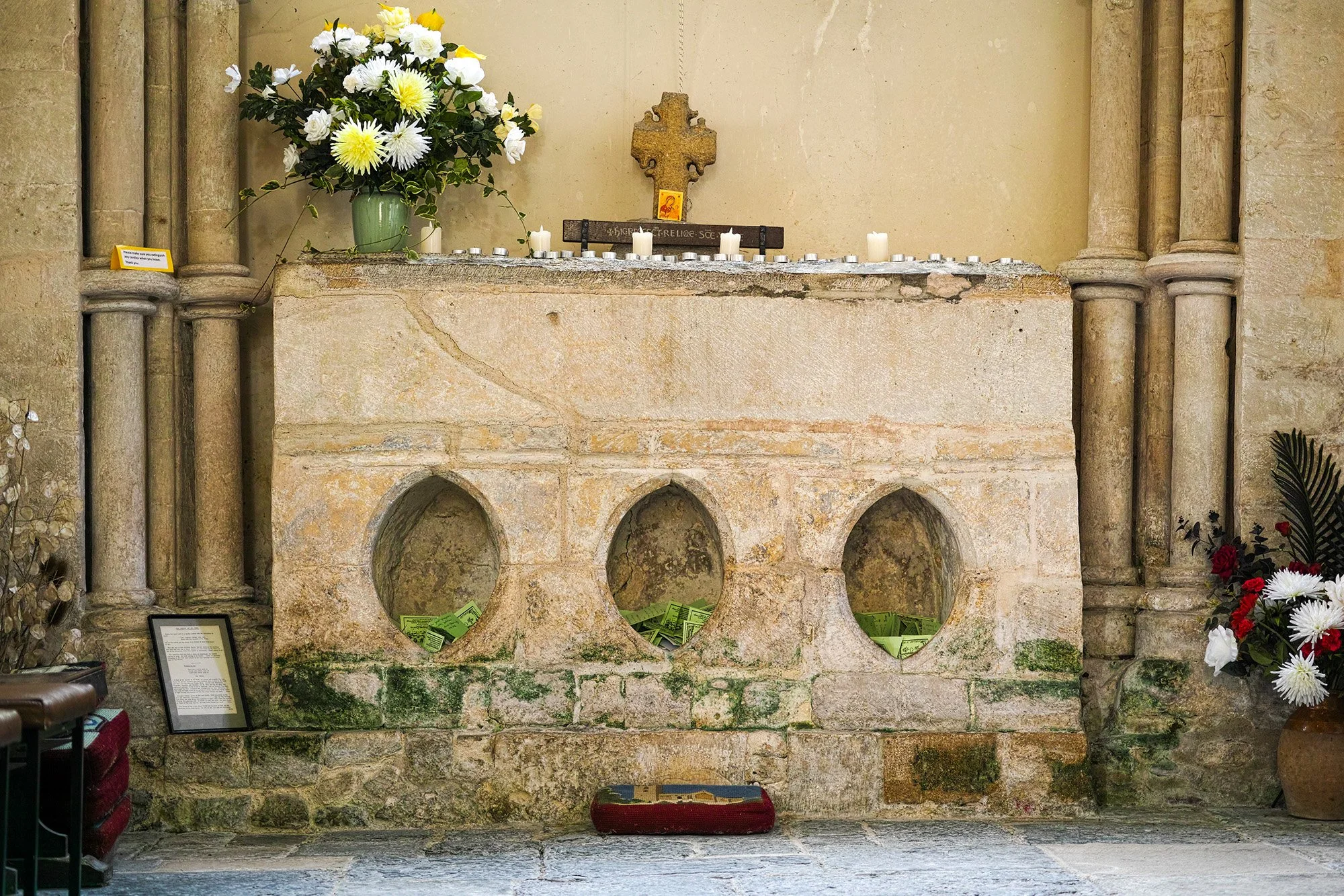
Evidence of a thriving pilgrimage tradition survives from the 15th Century, when William of Worcester tells us of pilgrim hostelries on the Crewkerne road being dedicated to St Wite. Recent metal-detecting in neighbouring fields has also uncovered lead ampullae, pilgrim souvenirs known for carrying holy water. In 1900, the vicar opened the shrine due to damage requiring repair, and found the bones of a woman aged 40 of short stature. She was re-sealed and put back in her shrine, where she remains today.
You don’t need to believe in the sanctity of ancient bodies to walk this pilgrimage. The aura of a holy place speaks for itself, and the continued reverence of pilgrims can be seen in the folded cards outlining needs and intentions. This flow of veneration builds and accretes, as you will feel it for yourself when you come here.
The stone hoops of the shrine are made for pilgrims to place their wounded bodyparts, or their heads, as closely as possible to the saintly remains. I recommend approaching with your question or need firmly in your mind, and placing your head into the stone hoops for as long as you need until an answer emerges.
The current vicar of the church has created a St Wita’s Way, which starts and ends at the church. But this does not incorporate the incredible hollow ways of Symondsbury, so I have made the alternative pilgrimage route, as outlined below.

St Wite’s Pilgrimage:
The Symondsbury Loop
Begin in Symondsbury, where there is ample free car-parking throughout the village. There is a public house here, the Ilchester Arms, serving excellent food. Fill your water bottle and use the loo here before you begin!
Visit the church of St John the Baptist before leaving the village. Speak your pilgrim intention aloud, the healing hope that motivates your making this pilgrimage. Be honest with yourself - what do you most truly need?
Walk north out the village, and the tarmac dissolves into a stone track between high trees. The hollow way of Shutes Lane begins. Walk slowly here, enjoying the peace and shelter of the trees and the sandstone banks. Look for the elaborate carvings, and stop to breathe in the ancient power of this pilgrimage path. Few places in the world are like this.
When Shutes Way diverges, take the left hand path down Hell Lane, another holloway. This is harder going, more rutted, and a spring halfway down emerges beneath the clay to create tricky conditions. At the foot of the lane is a ford, so be sure to tread nimbly or wear shoes capable of getting a little wet.
At the end of Hell Lane, continue forward onto Butt Lane. You will get house envy here, as the thatched deights of the hamlet would make a palace for any pilgrim.
The road - if such it may be called - soon becomes a track. Follow onward between newly planted hawthorns, and you will smell the sickly sweetness of Himalayan Balsam, an invasive plant that is getting an ever stronger grip on England’s ecosystems.
Where Butt Lane becomes tarmac again, you have reached Ryall. Continue straight along the road here, taking care to be seen by the very few cars who might pass. The road is single track, so people drive very slowly. You may well meet no-one.
Soon arrives the village of Whitchurch Canicorum. Pass the Five Bells pub - with loos and drinks and the optoin of camping! - and continue straight toward the spire of the church. The road turns into a small footpath beside a thatched cottage, which emerges by the eastern wall of the church.
St Candida and Holy Cross is the official name for the church. Candida was the late Medieval name for St Wite. You can see a modern depiction of the saint on the side of the tower, in sharp yellow stone. She appears to me like a pregnant lady bearing a flaming brand - surely a very ancient and powerful symbol indeed! Roman bricks can be seen in the tower structure, showing how old this foundation may be, and Saxon carvings of a ship and an axe can be seen high on the side of the tower too.
Enter the church (where there is a loo and tap), and take the cool peace. In the nothern corner lies the shrine of St Wite. Spend time here, sit in silence, offer your gifts of a lit candle and a cash donation if you can. Then enter the shrine, placing your head into one of the three alcoves, and ask your question or express your need. Hold stillness, and see what answer comes.
Leaving the church through the main gates, turn left at the war memorial, and right at the junction signposted toward Morecomblake. Head uphill, along the quiet wooded road, until you meet a junction. Turn left, and follow through the village.
You eventually meet the main road, which can be busy. Cross stright over, and leave this noise behind. Turn right at the junction, and left onto the footapth signposted for St Wite’s Well.
Follow until you see the holy well fenced on your right. Remove your hat, enter gently, and sit with the water. Be sure to offer a gift here - song is effective, if you carry no pure silver. Look out for any insects, birds or other animals nearby - the Arthurian tradition of the Well Maidens says they can take any form, and if you pay them respect, they can grant wellness… I wouldn’t drink this water without purification from a Grayl or similar device, due to sheep in the field close to the source.

14. Continue past St Wite’s holy well, and follow the track lined with pine trees. You will now see the sea! Walk on until the footpath offers a field route on your left. Make sure you get the right one! Follow this to the far corner, where it emerges onto St Gabriel’s bridge. Turn left, and left at the farmhouse, and you will enter the field with the ruined chapel of St Gabriel. Sit a while in here, and revisit your pilgrimage intention. Also be sure to drink water, and perhaps take a snack, as the climb ahead is steep…
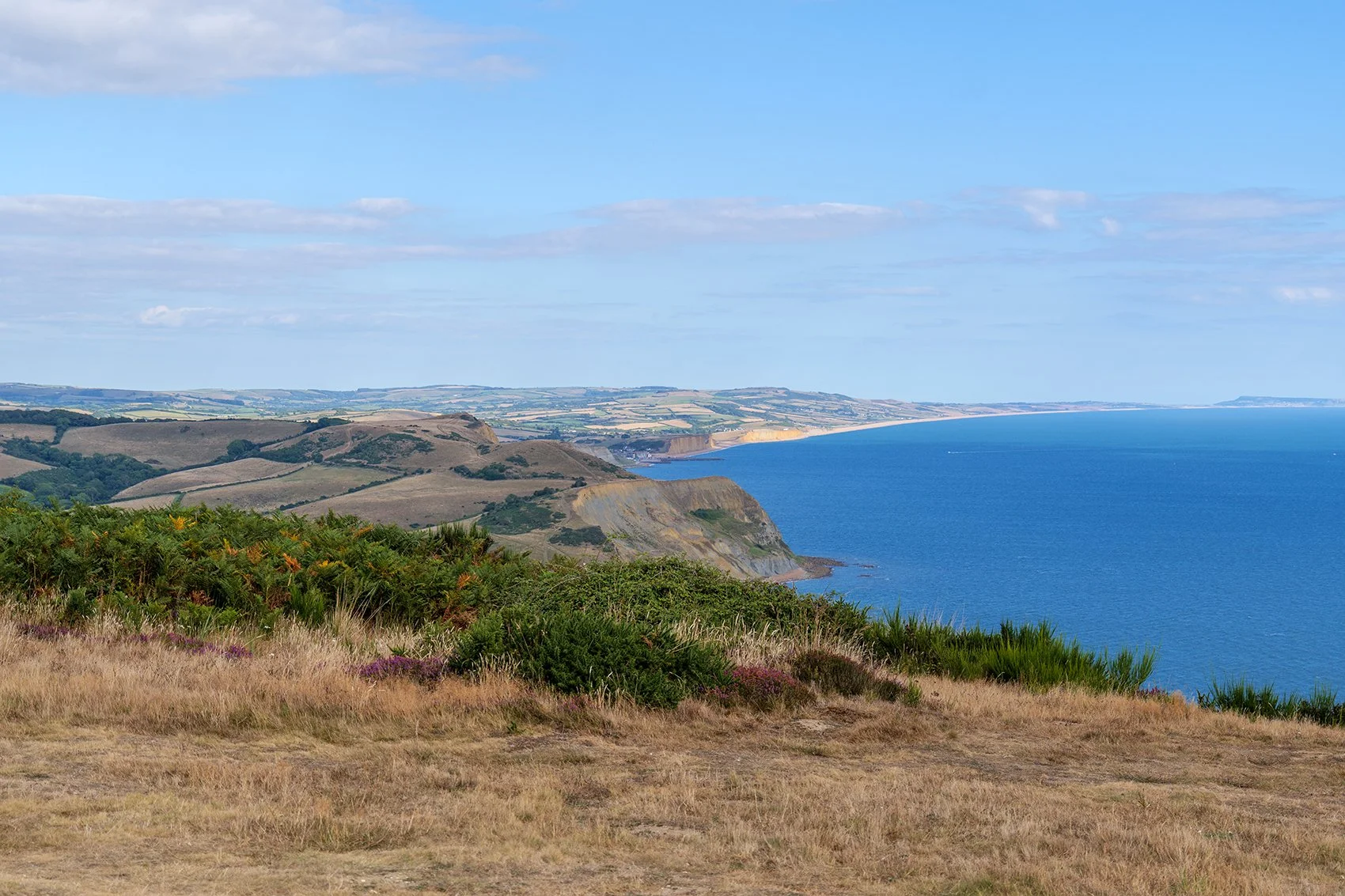
15. Follow the footpath to the foot of Golden Cap, and begin climbing thr steps upward. This is the highest hill on the south coast of England, named for the layer of sand at its top. When you reach the pinnacle, you’ll have 360 degree views of England and the sea. Relish this!
16. Walk to the trig point (the official highest point) and then begin to walk down the steps beyond. Keep to the footpath toward Chideock, known as Pettycrate Lane. This sandy track branches abruptly to the left, as the path plunges into what appears to be a straggly hedge. But beassured, this really is the path - here between the fields runs an exceptionally narrow holloway, a secret passage leading to the village of Chideock.
17. Emerging from this holloway, walk toward Chideock. Turn left and you reach the main road, where the church of St Giles stands. Behind this church is the Catholic mortuary chapel of St Our Lady and St Ignatius. When I walked here, neither were open. Perhaps you’ll have better luck?
18. Follow the main road for a few hundred metres, through what must have once been a peaceful and delightful village. Escape the traffic at Park Farm, and head toward the hills. Skirt the back of a barn, which opens up into pheasant land. Ascend the hill, cross the barbed wire, and you are on Quarry Hill.
19. To your right is a beacon for celebratory fires,while behind you is the beauty of Dorset’s small hills. Continue along the hillside until it meets the gate of Shute Lane, where your pilgrimage began.
20. Turn right down Shute Lane, the holloway you walked at the start of the day, and walk back toward Symondsbury.
Your pilgrimage is complete.
